


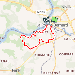
La Roche Bernard_Bords de Vilaine_10,6km

Pousscailleux
User

Length
10.6 km

Max alt
42 m

Uphill gradient
148 m
Km-Effort
12.5 km

Min alt
3 m

Downhill gradient
148 m
Boucle
Yes
Creation date :
2015-04-20 00:00:00.0
Updated on :
2015-04-20 00:00:00.0
2h43
Difficulty : Easy

FREE GPS app for hiking
 SityTrail
IGN / Geographical institutes
SityTrail Plus
The world is yours!
About
Trail Walking of 10.6 km to be discovered at Brittany, Morbihan, La Roche-Bernard. This trail is proposed by Pousscailleux.
Description
Départ du Parking La Voûte à La Roche Bernard.
Positioning
Country:
France
Region :
Brittany
Department/Province :
Morbihan
Municipality :
La Roche-Bernard
Location:
Unknown
Start:(Dec)
Start:(UTM)
552459 ; 5262893 (30T) N.
Comments